
A fine little park with beach access, camping, a boat launch and trails. A popular park in the summer, this is a great place for a quiet off-season hike. On this loop trail, there are views, a forest walk, birding and beachcombing.
Start your hike by hiking up the road to the hairpin turn. Just at the corner of the turn is a sign and the start of the Loop Trail. Follow this trail along the top of the bluff, looking down through the branches of the madrona trees to the beach and out across to the snowcapped Olympic Mountains. At each signed intersection follow the arrow for the Loop Trail. When you come to a sign for South Beach, follow the arrow and head down a series of sturdy stairs that will take you from the bluff to the beach. Once you get to the bottom, before crossing the little bridge and hitting the road, turn right onto the Marsh Trail. This nice alternative will take you between the edge of the woods and a marshy area alive with mixed flocks of small songbirds. See how many you can find in the brush!
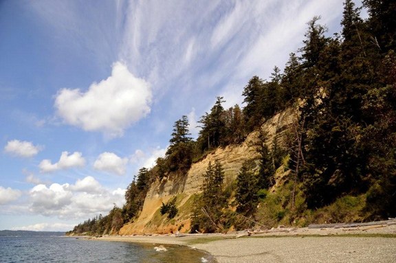
When you reach the end, you will be by the boat launch and looking up at the bluff you just looked down from! If you hit a low tide this area makes for some wonderful beach walking. Keep an eye peeled for eagles. After all the Saratoga Passage is also called the ‘Salmon Freeway’! Three major spawning rivers run into the Passage, the Skagit, Stillaguamish, and Snohomish. Notice the erosion going on at the top of the bluff, it is part of the ecosystem here. The sand deposits are carried to beaches by the tides and this creates habitat for eelgrass beds, which in turn creates a place for small forage fish used for food by the many inhabitants of the Sound and shoreline.
When you are done here, walk along the rocky beach by the picnic tables. Right where the rocks meet the soil, there is a yellow daisy -- Puget Sound gumplant -- that seems to boom all winter!
There are other trails besides hiking trails, and this park is on the Cascadia Marine Trail. The Marine Trail starts at the southern end of Puget Sound and goes all the way to Canada. You will find a map of it and a campsite at the end of the picnic tables. To camp here, you must have docked a human powered boat.
Head back uphill for the rest of the Loop, keeping right at the fork and climbing back up a short set of stairs. During periods of high runoff, look for the small waterfall on the left. At the top of the hill, the trail gets rather hard to follow as it weaves in, out and around campsites. You want the South Rim and Elger Bay Viewpoint trail. If you lose it, follow the road downhill a bit and pick it up on the left. This trail heads uphill through the forest, skirting the outer edge of the park. If you didn’t eat lunch on the beach, enjoy your sandwich on a nice bench here in the woods. Please respect the private property along the park border.
The next section is the Howard Adams section. There will be an intersection (unmarked at this writing). To the right is a dirt road, to the left is a paved park road. Follow the dirt road. Stay on this until you see a brown arrow pointing to the left and down. This marks the park boundary. Once you follow this trail down, you will end up a short way from the hairpin turn and your starting point.
Note that if the tide is out far enough, you can walk on the beach all the way down to the boat launch area, then pick up the Loop Trail from the boat launch area. Be sure to watch the tide, it can come all the way up to the base of the cliff, leaving you with no place to walk.
Extending Your Hike: Across the road from your ending point you can pick up the Cross Island trail and hike all the way to Cama Beach. There is also a nice little nature walk located in the center of the campground for little hikers.
Camano Island State Park

-
 Length
- 2.6 miles, roundtrip
-
 Elevation Gain
- 200 feet
-
 Highest Point
- 200 feet
A fine little park with beach access, camping, a boat launch and trails. A popular park in the summer, this is a great place for a quiet off-season hike. On this loop trail, there are views, a forest walk, birding and beachcombing.
Continue reading
Hiking Camano Island State Park
Map & Directions
 Trailhead
Before You Go
Parking Pass/Entry Fee
Discover PassWTA Pro Tip: Save a copy of our directions before you leave! App-based driving directions aren't always accurate and data connections may be unreliable as you drive to the trailhead.
Getting There
Head north on I 5 from Everett. Take exit 212 for Highway 532, signed Stanwood/Camano Island. After exiting the freeway, turn left at the light onto 532.
In 9.8 miles come to a Y, stay left (signed for parks). In eight miles, turn right onto Mountain View Road. There is a gas station/grocery store on the right just before the turn. In just under two miles turn left onto Lowell Point Rd.
In .7 miles drive into the park. Turn right and head downhill to the day use parking area. There is a large parking area, picnic tables and restrooms.


