NASA's Nighttime Maps Reveal Humanity's Impact on Earth
Advances in how satellites image the planet’s artificial lights are helping scientists estimate global patterns of energy use.
As seen from space, Earth looks quiet, and a bit lonely, during the day. Our blue marble is interspersed with the lush green of forests, but that’s about the only sign of life. It’s impossible to tell anyone is home, especially anyone who thinks, and moves around, and builds things. There are no political borders. There are no cities or ports or bridges.
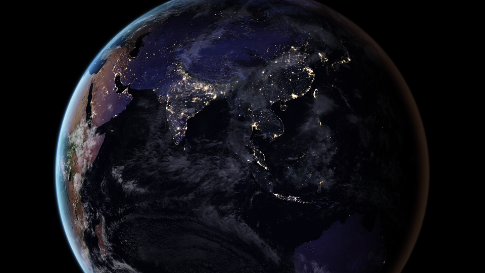
But look at night, and you will see a very different planet. The world’s metropolises glow yellow-white, as if someone sprinkled the continents with a dusting of tiny stars. You can follow rivers, railroads, and highways by the communities that cropped up along them. You can see boats in the open ocean. Artificial light is arguably the clearest sign that Earth is an inhabited planet. And it is one of the best ways to see changes in how we inhabit it.
During the past 25 years, NASA has used its fleet of satellites to put together a few maps of these lights, which you can download and hang in your office, and which researchers can use to study population trends, development, and other global-scale changes. No satellite has ever been built expressly to study these lights, so producing the maps is a challenge. But a new satellite that joined the fleet a few years ago has a light collector that’s easier to use, and sees with 250 times better resolution than before. Programmers are making computers smarter, allowing them to erase moonlight and atmospheric dust, leaving only the glow of human-made light.
Now, researchers are on the cusp of producing these maps not every decade, but every night. This will be a sea change in the way scientists study light at night, and how our dependence on it is changing our planet.
“To be honest, I don’t know what we’ll see. … Will we see just a steady glow all the time from cities? Or will we literally see cities blinking?” asks John Barentine, the program manager for the International Dark Sky Association. “The maps tell us so much about skyglow, but we have also learned an awful lot about humanity just by studying the patterns of where that light appears at night.”
Since November 2011, that data has come primarily from the new satellite, called Suomi NPP, which is an amalgam of a meteorologist’s name and an acronym soup that comprises NASA, NOAA, and the U.S. Department of Defense. It’s a weather satellite first and foremost, but it also has an instrument called the Visible Infrared Imager Radiometer Suite, which looks at Earth in visible light.
Researchers at NASA use VIIRS data to make maps of the Earth at night, but it’s not really designed for this purpose, explains Miguel Román of NASA’s Goddard Space Flight Center in Greenbelt, Md., who leads the team. “When you have an instrument like this, you end up with like a Swiss Army knife. You can do a lot of things, but you’re not particularly good at doing any of them,” he says.
The satellite’s first “black marble” image of the world, published in 2012, required 5,247 orbits and 20 terabytes—eight times the volume of the Library of Congress. It was a heavy lift, because the satellite isn’t really taking pictures. Rather, it is sensing different wavelengths of light to study multiple components of the Earth and its systems. It collects light in 22 different wavelengths, from green to near-infrared, much in the way a digital camera does—only its pixels capture stretches up to a half-mile wide. The pixels stream down from space into a ground station in Svalbard, Norway, and computer codes turn them into geophysical variables. Scientists write the codes based on the laws of nature and light, to the extent that we understand them.
“You have to have a science team that is constantly developing the theory, and understanding the behavior of that instrument. There’s a lot of work, and jobs, to ensure that we are not just taking pretty pictures that might end up as your iPhone background,” Román says.
His team manually generated the first black-marble maps, choosing pictures without clouds and moonshine. It took two months of work, and many of the satellite’s images weren’t usable. “With the moon, you’d just say, ‘Sorry, the moon is too hard to take out, and it’s too bright, so I can’t show whether that place is a city or it’s just moonshine.’ That’s when you have decided 50 percent of your data is trash,” Román says. “We said, ‘No. We don’t have 300 engineers building this satellite and launching it into space to trash it.’”
Román’s team has since been painstakingly crafting software that can account for moonlight, and essentially turn it off. This required improved calculations that explain the physics of how light radiates, scatters, and reflects. The team made a breakthrough earlier this year, and has started to build a consistent daily record of nighttime light, he says: “It doesn’t matter whether there is a moon, it doesn’t matter whether there is airglow [from pollution or auroras]; we can turn it off, and see only the light from cities.” The team can make a map within three hours of the satellite’s flight overhead, 512 miles above Earth.
Pictures from the years since the original black-marble image show a stunning degree of change. Take this new stretch of Interstate 90 outside Chicago, connecting the city to a suburb:
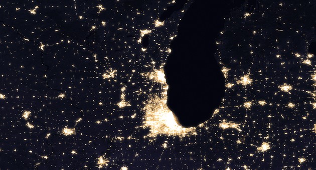
(Joshua Stevens / NASA / Miguel Román / Goddard Flight Center)
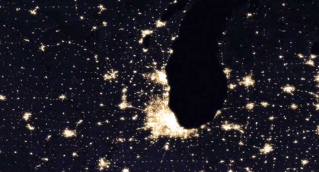
(Joshua Stevens / NASA / Miguel Román / Goddard Flight Center)
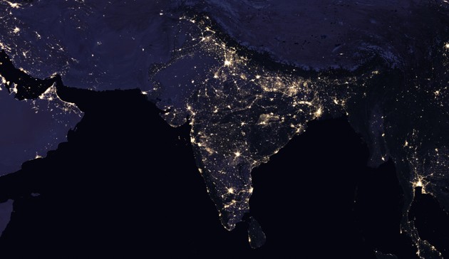
On a larger scale, the Indian subcontinent is much brighter in 2016 than it appeared in 2012, reflecting the breakneck pace of development there:
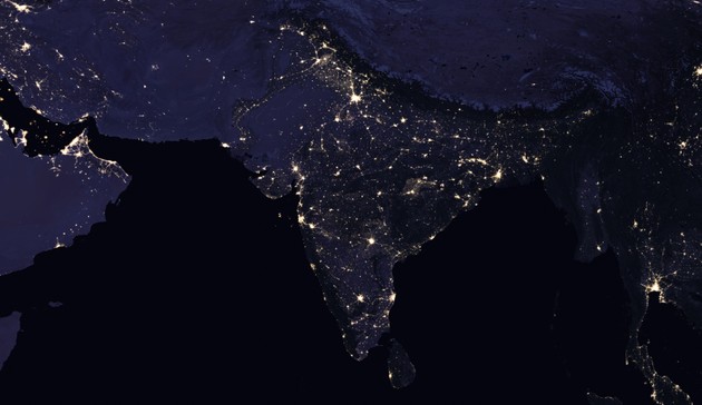
(Joshua Stevens / NASA / Miguel Román / Goddard Flight Center)
(Joshua Stevens / NASA / Miguel Román / Goddard Flight Center)
Román says the maps will be able to track power outages after natural disasters, and the changes taking place in conflict zones. Light streams from refugee camps just as people stream from Syria and Darfur.
Nightly images are useful in their own right, but they will also help to fulfill Suomi NPP’s larger goal of forecasting. By observing how nightly images change over time, researchers may be able to discern patterns, such as increased lighting in suburban areas during Christmas holiday season; or shifting energy use to after sunset during Ramadan; or the electrification of rural areas.
“We know, pretty much, who is buying LED lamps, how many cars we’re driving, and so forth. These are individual-scale factors. But there is a trove of information that is left to be explored on the energy-use patterns that are the result of wider, group-based activities,” Román says. “What is the energy required to live within a certain cultural context?”
And that’s saying nothing of the other creatures on this planet, all of which evolved with the promise of a dark night. Researchers are only beginning to study the effect of nighttime light on ecosystems, and nightly Suomi NPP maps will be crucial here, too.
Neil Carter, an ecologist at Boise State University, recently won a NASA grant to use the maps to study wildlife behavior and population patterns. “The way we develop policies is at large-scale levels—counties, parks, states,” he says. “We don’t want to focus necessarily on an individual animal, or even a part of the population, but the whole population. You might be asking questions about effects on bird species that occupy the entire Southeast, for instance. That’s where a satellite is useful. We’re excited about coming from the top down.”
That view from above is one only humans can obtain. And night after night, it’s the view that best illuminates the effect we are having on this planet.