 English
 Ελληνικά


-
Fast facts
Population 2021: 331 inhabitants
Older Censuses 2011: 406, 2001: 394, 1991: 406, 1981: 360, 1961: 496, 1928: 809, 1886: 553, 1869: 364 inhabitants
Population density per Km² 282 inhabitants
Village altitude 10 m
Region average altitude 13 m, mountainous
Village land area 0,08 km2
Region land area 1,17 km2
Economy relies mainly on agriculture (viticulture & olives), and tourism.
-
Description
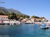
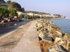
Agios Konstantinos village (Greek: Άγιος Κωνσταντίνος) or just “Agios”, as the locals call it, is located to the north of the island, by the seaside. The distances are: from Samos town 20 km, from Karlovasi town 12 Km, from Pythagorio village 30 Km and from Marathokampos village 25 Km.
Administratively consists the local communities of Agios Konstantinos, which belongs to Vathi municipal unit, of East Samos Municipality, with Samos city capital.
The village It has rich water sources and is surrounded with lush vegetation, the greatness of which is shown at “Platanakia” area that is almost united with the village. Restaurants and hotels operate there, under towering plane trees and other vegetation.
It is actually comprised out of two settlements, “Pano (or paleos) Agios Konstantinos” (upper or old) which is hidden behind the forest and from “Kato Agios Konstantinos” (lower), which was built later, in the beginning of the 19th century by the sea. Upper Agios Konstantinos is not inhabited for the past years apart for the summer season.
Agios Konstantinos is one of the few villages in Greece which do not have the classic square with plane trees and cafes. At the village the taverns, cafes and bars are scattered along the beach. The enlargement of the area in front of “Agios Ioannis” church, which replaces the square, is a recent construction.
top-
History
How and when Agios Konstantinos was created is not known precisely. It seems that it was created at end of 18th century, along with other settlements in the region, after the spread of the Vourliotes village’s inhabitants, since it is one of the oldest villages in the region (mentioned by the author I.Georgeirinis at 1670).
At first “Pano Agios Konstantinos” was created (upper) and during early 19th century “Kato Agios Konstantinos” (lower), was also created. At that time it was called “ormos” (=cove). Initially only some wine warehouses existed there.
In 1851, during the Samos hegemony period (1834-1912), “Manolates” with the villages Agios Konstandinos, Stavrinides, Ampelos, Valeontades, & Margarites (abandoned) they constituted the municipality of “Exi Geitonies” (=six neighbourhoods). At 1912 (union of Samos with Greece) it became an independent community.
top-
Name
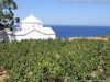
The name of the village derives from the homonym church, located in “Pano Agios Konstantinos” (upper), which was built at the middle of 18th century and it was a dependency of Vronta monastery.
top-
Settlements
One settlement belong to Agios Konstantinos village, Valeontades settlement, 4 Km south-east, with 1 inhabitant. The name derives from the surname “Valeontis”, it is mentioned in the 1928 census but it has been since abandoned.
top-
Tips
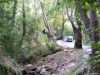
- Relax in the cool area of “Platanakia” (=little plane trees), east of the village (at the road to Manolates), below the rich shade of giant plane trees next to “kakorema” creek.
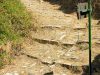
- From “panos Agios Konstantinos”, the old path that leads to the village “Stavrinides”, begins. It’s uphill but amidst lush greenery and beautiful view.
- Have lunch or dinner at the good taverns of the village and then get homemade ice cream or other sweets from the patisserie located on the main road to Karlovasi.

