Winter finally came to Michigan in a big way. This past weekend in Grand Rapids, we received about 17 inches of snow. Prior to that, the snowfall had been minimal. That was the case in the northern lower peninsula, as well. Frankfort, Michigan, in Benzie County, had just 2.5 inches of new snow in December, 21 fewer inches than normal. So far in January, Frankfort has received 21.8 inches.
With this blast on winter, I had to drive north to check it out and do some photography. On Wednesday, I visited the Point Betsie Lighthouse, just north of Frankfort, perhaps one of the most photographed lighthouses in Michigan. I arrived about 8:45 a.m. and had the place to myself. No wonder. The wind was gusting to 30 mph and the windchill was about ten below zero. I was able to stand outside for about 10 minutes before my fingers were so cold, it was hard to operate the camera. I retreated to my car, put on some heavier gloves, put foot warmers in my boots and headed up to the Sleeping Bear Dunes National Lakeshore, where I photographed in woodlands, where I was protected by the wind. My 10 minutes in the deep freeze were productive, however. Here are the keepers among the photos I took.
I had another chance to go north this weekend to try my hand at a little night sky photography. The last “Super Moon” of the year arrived on Thursday. As a bonus, mid-August is the peak of the Persied meteor shower. So, I planned a shot of the full moon the following night right between the silos of the D.H. Day Barn at the Sleeping Bear Dunes National Lakeshore. I used the Photopills app to determine where I needed to stand and the time I needed to be there to shoot the moon in all its glory above the barn. I was able to reserve one of the last available campsites at the D.H. Day campground and headed north.
In the afternoon, I used the augmented reality feature of Photopills at the D.H. Day farm to confirm that the shot would work. The photo below hints at the problem I would encounter. The wispy clouds in the sky are cirrus uncinus clouds. In Latin that means “curly hooks.” The clouds are commonly called “mare’s tails,” and are precursors of rain.
The sky was filled with mare’s tails. Things weren’t looking good, but I had several more hours before sundown and moonrise.
I decided to watch the sunset from Van’s Beach in Leland, Michigan. While waiting for the show, I snapped some photos of the boats in the harbor. The reflection of a sailboat’s mast caught my eye. I watched the reflection as it morphed with each passing boat.
It became clear that there would be no great sunset show and likely no shot of the moon over the D.H. Day barn. The clouds in the west were headed my way, fulfilling the prediction of the mare’s tails. I took a photo of the entrance to the harbor and then set upon my way, hoping the skies would be clear 20 miles to the southwest.
No such luck. At the D.H. Day farm, the sky was thick with clouds. I determined to go with my plan B, a shot of the Point Betsie lighthouse. Point Betsie was another 24 miles to the south. On the way, I stopped by the beach at Empire. There’s a small lighthouse there in the middle of a parking lot. When I got there, the parking lot was full of revelers enjoying the evening. The night was dark but there was a faint reflection on the water. An 11 second exposure looking into the darkness revealed what was barely visible to the naked eye.
Finally, I made it to Point Betsie. My goal was to get a shot of the light house with the lamp lighted. The challenge is that the lamp is so bright compared to the lighthouse itself that if you expose for the lighthouse, the lamp gets blown out and has no detail. But, I had a plan.
Every lighthouse has its own “signature.” Some lights rotate, some are stable. Some flash, while others stay lit constantly. The Coast Guard publishes a list of the signatures of every lighthouse and buoy in the country. I knew from the list that the Point Betsie light flashed white for one second every ten seconds. After much experimentation, I discovered that a 3.5 second exposure allowed for a proper balance between the lighthouse itself and the lamp. But the key was not having the shutter open for the full one second the lamp was on. I learned to open the shutter shortly after the lamp lit so that it was on for probably just a half second or less during my exposure. I was helped in getting a proper balance by the moon, which peaked through the clouds, lighting the side of the building. I augmented the moon’s light with a small light panel.
The photo reminds me of an Edward Hopper painting. Hopper, of course, lived and painted for many years on Cape Cod, an area that resembles the Leelanau Peninsula in many ways. His work has influenced many photographers.
Mission accomplished, I drove back to the campground and crawled into my sleeping bag about 1:30 a.m. I was awakened briefly at 3:00 a.m. by the sound of raindrops hitting my tent fly. Never doubt those mare’s tails!
I traveled north to the Leelanau Peninsula early Saturday morning. It was a snowy drive and took me about an hour longer than normal. But once I arrived and the sun came up, I was treated to awesome beauty.
My first stop was Point Betsie, shortly before sunrise. I was curious to see whether in the intervening weeks since I last visited (February 2) the ice had built up on the trees and bushes south of the lighthouse. While ice had built up on the breakwaters, the ice that had formed on the trees was not what it was three years ago when I visited in January. Back then the trees were thick with ice and the place was thick with photographers.
I ventured next to the Platte River near the point where it enters Lake Michigan. To get the perspective, I wanted I waded into knee deep snow. The scene was peaceful, interrupted only by a beaver swimming by and two swans that flew overhead making a terrible racket.
The needles of larches, or tamarack trees, typically turn a golden orange and fall to the ground in the fall. They are beautiful trees in their fall colors. This young larch on the river’s edge managed to hang onto its needles as a winter coat.
All along M22 the road and the trees were covered in snow. I seemed to have the place all to myself.
The trees glistened as the sun rose in the east. I pulled to the side of the road on M22 to get this shot of trees in an open field on the edge of the forest.
The scene below is Otter Creek where it crosses Aral Road in the Sleeping Bear Dunes National Lakeshore. This is the site of the town of Aral, a booming mill town in the 1880s. Nothing remains of the town today except for a large concrete block that likely served as a base for the sawmill that was about 25 yards east of this spot. An old map shows that this area is where the mill pond formed when Otter Creek was dammed.
Today, Otter Creek flows freely into Lake Michigan except, of course, in winter when shore ice builds and obstructs the the creek’s pathway, as shown in this photo. In the background on the right is Empire Bluff.
The Point Betsie lighthouse is located a few short miles north of Frankfort, Michigan, just west of Crystal Lake. It is a favorite location for photographers, especially in winter when the spray from the crashing waves covers the grounds with ice. To date, this winter has been so mild that little ice has formed, but Point Betsie never disappoints. I visited Point Betsie on Ground Hog’s Day, arriving shortly before 7:00 a.m. to scout it out and take some photos.
The lighthouse was completed in 1858 at the southern entrance to the treacherous Manitou Passage. Today, the Manitou Passage Underwater Preserve is a popular location for divers to explore 33 shipwrecks. A keeper’s house adjacent to the lighthouse, a fog horn and oil house were all added later. The lighthouse was automated in 1983, but the lighthouse was staffed by the Coast Guard until 1996. Today the lighthouse is owned by Benzie County and cared for by the Friends of the Point Betsie Lighthouse.
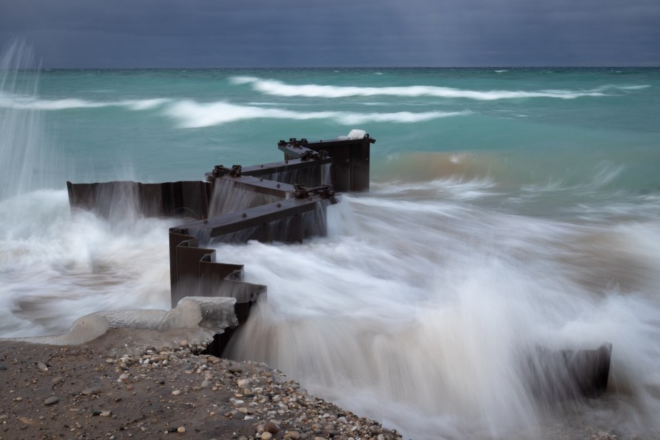
The Point takes a beating from the waves. The lighthouse is protected by a seawall of steel, an apron on concrete that extends from the seawall up to the lighthouse, and a series of steel breakwaters all of which date back 75 years. But the shoreline protection system is in need of repair as Lake Michigan’s historically high waters take their toll. The concrete apron has an widening crack, which gets exacerbated in the winter when ice forms and expands. Efforts are underway to raise $1 million to repair the protection system.
Even when riled up by the wind and waves, Lake Michigan is a beautiful shade of blue.
The fury of the lake is awe inspiring. On Ground Hog’s Day, the wind was out of the north at a steady 20 mph, gusting to close to 30 mph.
Here are a few sequences of waves crashing against the breakwaters.
Before leaving to explore other areas, I took one last shot of the lighthouse standing guard as it has for 163 years. Point Betsie is one of the country’s most photographed lighthouses. There are many photographers who have captured images here. The thrill of photographing at Point Betsie is not so much the chance to get a photo no one else has captured, but the excitement of feeling nature’s power and capturing it in an image.
What a weekend. Two days of perfectly clear skies. Temperatures in the 40s. I used the occasion to head north to the Leelanau Peninsula . I had hoped for some dramatic wave action. The forecast of a steady 20 MPH wind gusting to near 40 got me hoping some big waves.
I started my day at Point Betsie, which is known for big waves and incredible ice formations. There were waves, but not the monsters I had hoped for.
Instead, Point Betsie was remarkably serene. There were waves hitting the sea wall that has been built to protect the lighthouse. Still, I had to keep wiping my lens to keep it dry, and I too got wet from the spray.
But, I had Point Betsie to myself for nearly two hours.
The beach at Point Betsie is littered with trees that have fallen into Lake Michigan. The Lake is at or near its highest level since 1986, chewing away at beaches and toppling not only trees but also houses into the lake. The fact that Lake Michigan did not freeze this winter has only exacerbated the problem.
After Point Betsie, I stopped at Esch Road Beach, Empire Beach and Lane Beach on Point Oneida in search of big waves, but nothing. So I drove up to Leland.
Historic Fishtown has been in the news for months now because of high water threatening the old fishing shanties. I wanted to see it for myself. The water wasn’t as high as I anticipated. Nonetheless, work continues to save Fishtown. They removed the Cheese Shanty this winter to rebuilt and raise the foundation it stands on.
Leland is the home port of the Mishe Mokwa (mother bear). which ferries day hikers and campers to South Manitou Island in Sleeping Bear National Lakeshore.
Pancake ice in the Leland Harbor.
Leland is also home to Van’s Beach. The water is an amazing shade of aqua.
Whaleback hill juts out into Lake Michigan at the south end of Van’s Beach.
Ice on Van’s Beach and on the breakwater that guards the entrance to the Leland harbor.
On the way home, I stopped once again at Point Betsie. The wind had picked up during the afternoon and I hoped that meant big waves backlit by the setting sun.
I wasn’t disappointed. They weren’t the giants I had hoped for, but they were enough for me to declare victory and begin the 3 hour drive home.
The “Big Lake” has been angry the past few days, with red flags warning swimmers not to go into the water. The lake has, sadly, claimed 19 people so far this year. These photos taken yesterday at the Point Betsie lighthouse show the power and the beauty of the lake.
The Point Betsie lighthouse before dawn.
Waves crashing against the bulwark that protects the lighthouse.
Waves crashing over the breakwater at Point Betsie.