These two trails have been hanging over my head as partials, half done, since August 2010. Today I officially check them off the list. I decide to redo all of Hyatt Ridge, and park my car at its trailhead. Beech Gap is a 1.3 mile walk up Straight Fork Road where one half of that trail begins its ascent to Hyatt Ridge.
Beech Gap Trail is split into two separate sections, both originating in an area known as Round Bottom off Straight Fork Road but heading in opposite directions — one climbing 2.8 miles to Hyatt Ridge, one 2.5 miles to Balsam Mountain. The section remaining for me to hike is the former, often noted as Beech Gap Trail II. It begins just before the Straight Fork bridge. Cross the bridge and walk the road a short distance to reach Beech Gap Trail I.
Taking a photo of the trail sign, I am plunged into confusion! An arrow points left with “2.5 miles to Straight Fork Rd.” The road is less than ten feet away. Another left arrow indicates Hyatt Ridge Trail is 5.5 miles away. Hyatt Ridge is either 1.3 miles down the road or 2.8 miles up Beech Gap. Then it hits me, this particular Beech Gap sign should be placed at the Balsam Mountain Trail junction. Whoever put it up wasn’t paying very close attention! Wonder what the sign on Balsam says? I sent photos to park officials. They were appreciative, “That’s a really wrong one!”
This section of Beech Gap isn’t totally new to me either. I participated in a fern survey on the lower stretch several years ago. I liked the trail and have been looking forward to hiking it. Today is also my ‘easy day,’ just 9.4 miles. I can take my time and enjoy life on this lovely day in May. Beech Gap Trail II proves a perfect match.
Straight Fork begins its journey on Balsam Mountain near Mount Yonaguska. Feeder streams from a broken series of ridges, including Hyatt, to the west and Balsam to the east flow into its lengthy and remarkably straight course. As the river nears the road, unnamed spur ridges from Hyatt and Balsam converge to form a narrow opening accommodating the river and two stretches of the road doubled back on itself. The two arms of Beech Gap Trail splay into a ‘V’ as each works its way up these spur ridges. Beech Gap II undulates along the northeast slope of its spur and overlooks the river’s deep valley.
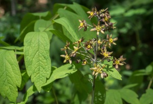
This northeast aspect encourages a richly diverse floral community, making the trail a wildflower lover’s dream. The trail moves in and out of folds along the wrinkled spur, many with small streams or seeps. The folds and seeps are particularly lush, but the entire trail is nothing short of spectacular. It’s simpler to list what I didn’t see, most notably Doll’s Eyes and Fringed Phacelia, but I could have easily missed both. Hillsides of Solomon’s Plume and Trillium grandiflorum mark either end of the trail that includes Large-flowered Bellwort, Cucumber Magnolia, Dwarf Ginseng, and Vasey’s Trillium.
The trail itself is quite smooth and never too narrow with only a mucky area or two to mar it thanks to horse traffic. The climb is steady but not taxing (1,800 feet). Of course, I stop every few yards to gawk at something. If a great Smokies trail and great mountain weather aren’t enough, a Wood Thrush begins to sing. We can’t chose our time and place of parting, but if I could, reclining in Beech Gap’s spring splendor listening to a Wood Thrush would be hard to beat. That’s my kind of rapture.
About a half mile from its terminus on Hyatt Ridge, Beech Gap II reaches a saddle or false gap, a wide and level spot with cooling breezes just perfect for a break or even lunch on a lazy day before heading back down. However, I highly recommend continuing to the ridge, visible northwest of the gap. The remaining climb is no more difficult than the rest of Beech Gap, and Hyatt’s ridge line has its own unique charms, particularly the section leading to Campsite #44 at McGee Spring.
The Beech Gap/Hyatt junction is 0.9 mile from Hyatt Ridge Trail’s upper terminus at the campsite. The trail slips around the western side of Hyatt Bald to reach the narrow ridge crest then turns left, following that crest through Red Spruce and northern hardwoods. No mistaking this ridge line. Sloping terrain falls to either side of the level path.
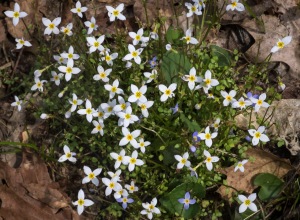
Trout Lilies and Wood Anemones are flowering, and Appalachian Bunch Flower and Turk’s Cap Lily will get their turn in summer. It is impossible to ignore thick tufts of Thyme-leaved Bluets (Houstonia serpyllifolia), sunny as a clear sky, and like the bright smiles of babies, impossible to see without smiling back. Today on Hyatt and yesterday on Grassy Branch I find not only the traditional blue-colored flowers, but some that are snow-white with yellow eyes.
HRT deviates from Hyatt Ridge, heading left on a course toward Breakneck Ridge, a place name that carries its own warning. Breakneck extends due west into the Raven Fork watershed, but HRT quickly turns right into a broad saddle between the two ridges and a gradual descent to McGee Spring. This spring is the headwaters for a feeder stream into Right Fork, one of three arms that converge into Raven Fork draining the Smokies Crest from Hyatt Ridge at Tricorner Knob to Hughes Ridge at Pecks Corner.
The broad saddle supports an open woodland generously sprinkled with grasses, wildflowers, still leafless hardwoods, and a few spruce. It’s an incredibly beautiful and peaceful spot. At the saddle’s far end, food cables and a fire ring of rocks denote Campsite #44.
Viewing the site from behind, a large boggy area on the front right corner supports thick green vegetation of Tassel Rue, False Hellebore, and Cutleaf Coneflower and marks the modest beginnings of McGee Spring. This mass of foliage ‘flows’ northwest with the spring through a sag. A wooded path on the left leads to an equally modest gurgle of water spilling over rocks for campers’ use. The sound of flowing water is stronger further down, but accessibility could be trickier.
Campsite #44 has capacity for 12 people and four horses. The space is wide and roomy, but in my wanderings I only noticed the one main area. It’s certainly big enough to handle several people, yet I can’t help but wonder if there are additional sites elsewhere. Checking the few paths that strayed from this hub, I found no obvious evidence of other locations.
Accounts of #44 note its damp underpinnings. I can certainly see where that could be a real issue. One thing they don’t note though is the relative lack of flat sites. Everything around the central fire ring is on a slight but noticeable slant. Not a problem until bedtime when you keep sliding into the downhill side of your tent.
I eat lunch and listen to the stereo call-and-response of two Black-throated Blue Warblers reinforcing their territorial boundary, which must run through the center of camp. No other sounds disturb the serenity. It really is lovely here, and I am reluctant to leave. However, 4.4 miles of sometimes steep downhill stand between me and my car. Clouds are building up too.
From McGee Spring, Hyatt Ridge Trail steps down the main ridge, alternating level runs and descending sections, sometimes treading the ridge crest, sometimes veering west of knobs. A few cool plants are here — Large White Trillium, Cinnamon Fern, Wood Anemone, and carpets of Canada Mayflower. As Red Spruce drops out, the western exposures are dry, rocky, rutted, and dominated by Mountain Laurel with Trailing Arbutus and Teaberry. One short section is very steep, pitching straight down the nose of the ridge.
HRT’s upper 2.6 miles range in elevation between 5,200 feet at Hyatt Bald and 4,400 feet at the Enloe Creek Trail junction, a wide level gap with ample room to spread out and take a break. Hyatt’s ridge line and upper trail ‘T’ into the gap with Enloe Creek Trail beginning to the right, and HRT continuing to the left. The final 1.8 miles drop 1500 feet. This steeper pitch is offset somewhat by the wider path of a graded road or railway remnant from spruce logging operations for WWI military planes. Intermittent rocky areas are annoyances. I’ve climbed this stretch in the heat of August, and believe me, rocks or no rocks, walking down in May is the way to go.
The ‘little brown book’ notes the presence of banded gneiss not far from the gap at Enloe. I examine every rock for a half mile. Many contain quartz and appear to have faint striping. Most online photos of this rock type show more pronounced banding, but a few resemble the look of HRT’s rocks. I haven’t the knowledge to state yea or nay, but the best image I have is posted. Maybe someone with more geology skills will chime in…Scott?
Between Enloe Creek Trail and the crossing of Hyatt Creek about 0.8 mile down, the trail cuts across a very steep hillside below Hyatt Ridge facing east into the carved ravine of Hyatt Creek and its tributaries. Cradled by the towering ridge and protecting cove, the relatively lush herbaceous layer hosts a diversity of species. Scanning the trailsides to compile a list as I walk, a unique trillium stops me cold.
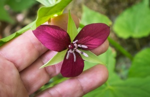
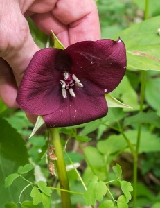
It’s the size of a Vasey’s Trillium with the flower tucked below a dinner-plate whorl of green leaves, but the recurved petals are white. Other details are odd: petal width varies from narrow to wide but not overlapping, petal texture appears thinner, anther sacks are purplish to ashy gray, ovaries are purplish red with bits of white. These details match Southern Nodding Trillium (Trillium rugelii).
However, there’s also a red-flowered version with narrow petals, and one that bears all the hallmarks of a true Vasey’s Trillium. I may have stepped into the middle of hybrid swarm! Several of the pedicellate (or pedunculate) trilliums listed for the park — T. erectum, T. simile, T. flexipes, T. vaseyi, and T. rugelii — belong to the “Erectum Group,” characterized by rhombic leaves and six-angled ovaries. Flower stalks of the last two species dip below the leaves. In areas where any of these species overlap, the possibility of hybridization exists.
More plants are visible downslope, but the steep hillside prevents me from checking more than a handful of individuals next to the trail. Two are classic white T. rugelii; one seems classic red T. vaseyi. Others show variation in petal width and the degree to which they are reflexed, both white and red, but anther color tends toward purplish. Flower color intergrades of rose and pink are possible including bicolor, but none exhibited these colorations that I could see.
HRT continues its sharp descent, crossing Hyatt Creek and following the stream course into Round Bottom. The grade finally moderates about a quarter mile from Straight Fork Road.
It’s sunny as I finish the trail and drive back to Big Cove Road
in Cherokee. Within a few minutes big rain drops hit the windshield. I reach Oconaluftee Visitor Center in a driving rain storm. Pulling into Smokemont, pea-sized hail bounces off the car hood. Lightning, thunder, and a second round of hail keep me stuck in my car at the campsite for an hour. I finally give up and drive back to Cherokee looking for an open restaurant.
The choice seems to be Hardee’s or Happy Garden Chinese Buffet. I warily choose Chinese, and it is fairly good…a bit of a surprise considering it’s in Cherokee, NC. Double helpings of General Tsao’s chicken and vegetable lo mein, along with green beans, egg-drop soup, two egg rolls, and a few other bits take my mind off the rain.
Driving up Highway 441 to Smokemont in the evening light, I come upon an ‘elk jam.’ Before dinner, two or three of the large grazers were standing in an open field. Now, there are over a dozen, a loose herd of mothers and yearlings, most bedded down in the wet grass. The felted knobs of new antlers are visible on a few. I stop to enjoy the sight and take photos. The rain, thankfully, has ended.


