
Peazens
Peazens | |
|---|---|
Village | |
 St Anthony's church | |
 Flag  Coat of arms | |
 Location in the former Dongeradeel municipality | |
 Peazens Location in the Netherlands  Peazens Peazens (Netherlands) | |
| Coordinates: 53°24′7″N 6°4′57″E / 53.40194°N 6.08250°E | |
| Country | |
| Province | |
| Municipality | Noardeast-Fryslân |
| Area | |
| • Total | 3.63 km2 (1.40 sq mi) |
| Elevation | 1.3 m (4.3 ft) |
| Population (2021)[1] | |
| • Total | 230 |
| • Density | 63/km2 (160/sq mi) |
| Postal code | 9136[1] |
| Dialing code | 0519 |
Peazens is a village in Noardeast-Fryslân in the province of Friesland, the Netherlands. It has a population of around 242 in January 2017.[3] Before 2019, the village was part of the Dongeradeel municipality.
There is a restored windmill in the village, De Hond. Peazens is twinned with Moddergat, and they are often referred to as "Peazens-Moddergat".[4][5]
History[edit]
The village was first mentioned in 1415 as pazene wal. The etymology is unclear.[6] The village of Peazens was founded in the 11th on the new dike along the Wadden Sea. Moddergat was founded later from Peazens, and used to consist of two hamlets: De Kamp and De Oere.[4]
The Dutch Reformed church dates from around 1200. In 1792, the tower was demolished and the church was extended into the vacant area. Afterwards a new tower was constructed.[4] The grist mill De Hond was built in 1861. By 1968, it had become a ruin, and was sold for ƒ1,- to De Hollandsche Molen Foundation. Between 1969 and 1971, it was restored and is occasionally in use.[7]
In 1840, Peazens was home to 637 people. Peazens used to belong to the municipality of Oostdongeradeel and Moddergat to Westdongeradeel. In 1983, the municipalities merged.[5]
The village's official name was changed from Paesens to Peazens in 2023.[8][9]
Gallery[edit]
-
 Village view
 -
 Village along the dike
 -
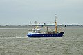 Wadden Sea with Peazens in the background
 -
 Windmill De Hond

_-_panoramio_(5).jpg)

_-_panoramio_(8).jpg)
References[edit]
- ^ a b c "Kerncijfers wijken en buurten 2021". Central Bureau of Statistics. Retrieved 1 April 2022.
two entries
- ^ "Postcodetool for 9136DD". Actueel Hoogtebestand Nederland (in Dutch). Het Waterschapshuis. Retrieved 1 April 2022.
- ^ Aantal inwoners per woonplaats in Dongeradeel op 1 januari 2017 Archived 2017-10-21 at the Wayback Machine - Dongeradeel
- ^ a b c Ronald Stenvert & Sabine Broekhoven (2000). "Paesens-Moddergat" (in Dutch). Zwolle: Waanders. ISBN 90 400 9476 4. Retrieved 1 April 2022.
- ^ a b "Paesens-Moddergat". Plaatsengids (in Dutch). Retrieved 1 April 2022.
- ^ "Paesens - (geografische naam)". Etymologiebank (in Dutch). Retrieved 1 April 2022.
- ^ "De Hond". Molendatabase (in Dutch). Retrieved 1 April 2022.
- ^ "22 dorpen in Noardeast-Fryslân krijgen op 1 januari 2023 een nieuwe Friese naam" [22 villages in Noardeast-Fryslân will receive a new Frisian name on 1 January 2023]. RTV NOF (in Dutch). 10 December 2022. Retrieved 7 April 2023.
- ^ "Friese namen" [Frisian names]. Taalunie (in Dutch). Retrieved 7 April 2023.
External links[edit]
![]() Media related to Peazens at Wikimedia Commons
Media related to Peazens at Wikimedia Commons